
Skip to content
The Encyclopedia of Horology

Tool · Scientific instrument / sundial and qibla indicator

A Safavid Mecca-centred World Map

Partially verified

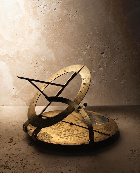
Dating to 17th-century Safavid Persia, this scientific instrument is composed of an engraved brass base plate measuring 22.5 cm in diameter. The plate features a retroazimuthal cartographical grid centred on Mecca to ascertain qibla orientation and distance, accompanied by a centrally pivoted rotating brass diametrical rule. An applied hinged sundial ring with gnomon is attached at the upper edge, supported by a hinged latitude arc, while a glazed circular recess for a compass is positioned on the lower portion. Persian inscriptions in thuluth script record poetic operating verses and name the maker as Husayn alongside the patron Sayf al-Dawlah.

Angled view of the Safavid brass Mecca-centred world map with raised sundial ring and glazed compass well
Angled view of the Safavid brass Mecca-centred world map with raised sundial ring and glazed compass well — Bonhams. Rights pending — permission not yet requested. Original source

Catalogue identity

Source
www.bonhams.com
Category
Tool · Scientific instrument / sundial and qibla indicator
Maker / attribution
Husayn
Reference
Not recorded
Catalogue / lot identifier
192P
Source-reported date
17th Century
Country
Iran

Source-reported attribution and specifications are not independent authentication. A listing does not establish present ownership, current display, availability or permission to reproduce.

Object description

Physical Configuration

The instrument features a circular brass base plate measuring 22.5 cm in diameter. The plate is engraved with an elliptical coordinate grid, with vertical and horizontal axes denoting longitude and latitude. The grid is surrounded by four cartouches containing inscriptions in thuluth script on stippled grounds with scrolling tendrils, while the border includes additional inscription-filled cartouches indicating bearings.

Mechanical components include a centrally pivoted rotating brass diametrical rule secured by a removable pin, and a glazed circular compass recess on the lower portion of the plate. The upper edge is fitted with an applied hinged sundial ring featuring an integrated central gnomon, supported by a curved hinged latitude arc on the left side. The reverse features two applied splayed brass feet.

Evidence for this section
  • “the circular brass base plate with centrally-pivoted rotating brass diametrical rule fixed with removable pin”
  • “a glazed circular recess for compass to lower part”
  • “the base plate finely engraved and chased with an elliptical grid”
  • “applied hinged sundial to upper edge, hinged latitude arc to left hand side”
  • “22.5 cm. diam.”

Historical Context and Attribution

The instrument is attributed to 17th-century Safavid Persia. Inscriptions identify the maker as 'Husayn' and the patron as 'Sayf al-Dawlah'. Scholarly sources describe both identities as elusive, noting that 'Sayf al-Dawlah' is an honorific meaning 'Protector of the Realm'.

Researchers designate this instrument as 'Map C' within a group of three discovered Mecca-centred world maps. Unlike other examples, such as Map 'A', this instrument is signed by the maker and includes the sundial armature, latitude arc, and inscription-filled cartouches.

Evidence for this section
  • “The fourth cartouche names both an instrument maker and a patron, whose identities remain elusive.”
  • “The maker is identified only as Husayn”
  • “The equally elusive Sayf Al-Dawlah is identified as the patron of the instrument”
  • “The present example, which Dr King has labelled "C", is the only instrument which is both signed and inscribed with an honorific”

Cartographical and Mathematical Function

The instrument is designed to determine the qibla—the direction to Mecca—and the distance from a given location. The projection used on the grid is reported to preserve angles from the center (Mecca) and the sine of the distance.

The instrument contains coordinate data for 102 locations, which source text associates with a mid-15th-century Timurid geographical table. The mathematical foundation for the grid is characterized as a product of Islamic scientific tradition, specifically using conic sections.

Evidence for this section
  • “The 102 localities on Map "C" and their correctly-computed qibla and distance values are to be found in this table”
  • “grid does not distort angles from the centre point (Mecca) or the sine of the distance to Mecca”
  • “the values for longitude and latitude for cities included on this instrument derived from a lost Timurid geographical table”

Open research questions

  • What is the specific mechanical or visual evidence for the original presence of a compass needle in the glazed recess?
  • Can the 'pseudo-Hasan Husayn' hypothesis be further verified through material analysis of the engraving techniques?

Source evidence

Recorded claims and source quotations for A Safavid Mecca-centred World Map
FieldSource-reported valueSource quotation
Plate Diameter22.5 cm“22.5 cm. diam.; the box 25.5 cm. diam.”
Base Plate ConstructionCircular brass plate with centrally-pivoted rotating rule“the circular brass base plate with centrally-pivoted rotating brass diametrical rule fixed with removable pin”
Sundial AssemblyApplied hinged sundial and lateral latitude arc“applied hinged sundial to upper edge, hinged latitude arc to left hand side”
Compass WellGlazed circular recess“a glazed circular recess for compass to lower part”
Inscribed MakerHusayn“Through the beauty of his craft Husayn has created a World on a page”
Box Dimensions25.5 cm“the box 25.5 cm. diam.”
Box ConstructionHexadecagonal wood with rayskin cladding“the hexadecagonal wood box with hinged lid, silver hinges and clasp, entirely clad in rayskin”

Visible details

  • Circular brass base plate engraved with an elliptical coordinate grid and inscription cartouches.
  • Elevated hinged circular sundial ring with an integrated central gnomon.
  • Curved hinged latitude arc supporting the sundial ring at an angle.
  • Glazed circular compass well situated on the lower portion of the plate.
  • Centrally pivoted brass diametrical rule extending across the base plate.

Research qualifications

  • The identities of the maker Husayn and the patron Sayf al-Dawlah are reported in inscription verse translations but remain historically elusive according to scholars.
  • Source notes map 'A' lacked a compass needle, but the presence or absence of an original needle inside this example's glazed recess is not explicitly detailed in the text.

Photograph identity and source facts were screened before import; rights clearance remains pending.

Consulted source

Bonhams : A Safavid Mecca-centred World Map Persia, 17th Century

Reviewed 2026-10-25 · Record efbe716728

Terms in this record

Glossary explanations for terms named in this object’s record.